
The Bossington Hill circular walk is a spectacular 6.5-mile route that starts and ends in Bossington village. Along the way, you’ll follow the South West Coast Path, wander through ancient Selworthy Woods, explore an Iron Age hillfort, and climb to the summit of Selworthy Beacon with breathtaking views across the Bristol Channel. This moderate walk typically takes around 3 to 4 hours and showcases some of the most treasured landscapes in Exmoor National Park.
Planning Your Bossington Hill Walk?
Stay right at the start of the walk! Browse our collection of holiday cottages in and around Selworthy – steps from the trailhead. 
⚡ Walk Stats at a Glance
📋 Complete Bossington Hill Circular Walk Guide:
🗺️ Bossington Hill Circular Walk: Route Overview
This magnificent Bossington Hill circular walk showcases some of the finest landscapes in Exmoor National Park. Starting from the picture-perfect hamlet of Bossington with its thatched cottages, the route initially follows the South West Coast Path around dramatic Hurlstone Point. From here, you’ll enjoy stunning views across Porlock Bay and the Bristol Channel.
After the coastal section, the walk descends through the beautiful Lynch Combe and into Selworthy Woods. These woodlands were planted by the Acland family in the 19th century. Remarkably, the 10th Baronet planted over a million trees on the hillside. He also laid out more than 40 miles of footpaths and rides between them.
The route then reaches the famous whitewashed cottages of Selworthy Green. Here you can stop for cream tea at the legendary Periwinkle Tearoom. Afterwards, the path climbs through more woodland to explore Bury Castle. This atmospheric Iron Age hillfort dates to around 400 BC.
The highlight comes at Selworthy Beacon (308m). On clear days, the panoramic views extend across the Bristol Channel to the Welsh coast. You can also see west along the Exmoor coastline and south across the rolling moorland. Finally, the return journey follows the South West Coast Path back to Bossington.
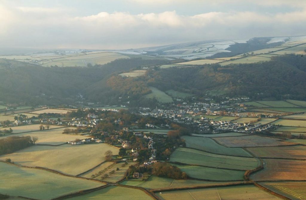
Photo by Neville Stanikk
Who Is This Walk Suitable For?
Classified as moderate, this walk is suitable for:
- ✅ Regular walkers with good fitness levels
- ✅ Families with older children (10+) comfortable with longer walks
- ✅ Dog walkers (livestock present – leads required throughout)
- ✅ History enthusiasts interested in the Acland family estate and Iron Age heritage
- ✅ Photographers seeking coastal views, woodland scenes, and picture-perfect villages
- ✅ Anyone seeking varied Exmoor landscapes in a half-day to full-day walk
⚠️ Not suitable for: Pushchairs, wheelchairs, very young children, or complete beginners uncomfortable with sustained climbs and 6+ mile distances. 🏘️ Bossington & Allerford Village Guide – Complete guide to Bossington with all facilities and attractions
👣 Detailed Walking Directions: Complete Route
📍 Stage 1: Bossington to Hurlstone Combe
Grid Reference (Start): SS 897 479
Distance: 0 to 1.2 miles From the National Trust car park in Bossington, head northeast along a wide grassy path towards the coast. The path is well-defined and climbs gently through open grassland. As you gain height, views open up across Porlock Bay. Soon you’ll join the South West Coast Path. Continue on the SWCP, ignoring the path on the right signposted to the “rugged coast path”. The route climbs steadily westward, with increasingly spectacular views across the Bristol Channel towards Wales. Keep following the coast path until you reach the top of Hurlstone Combe, where the landscape opens dramatically before you.
What to look for: Views across Porlock Bay to Porlock Weir are magnificent from this section. On clear days, the Welsh coast is clearly visible. In addition, look for fulmars and other seabirds along the cliffs here.
📍 Stage 2: Around Bossington Hill to Lynch Combe
Grid Reference: SS 899 484
Cumulative Distance: 1.2 to 2 miles At Hurlstone Combe, bear left onto the footpath signposted ‘Lynch Combe 1’. This delightful path skirts around the side of Bossington Hill (243m), offering wonderful views across the vale below. The trail first dips through Church Combe before entering shaded woodland. Next, the path crosses Lynch Combe, where you’ll see a signpost marked ‘Footpath Allerford ¾’. Pass through a gate here and continue ahead. Follow signs for ‘St Agnes Fountain, Allerford, Bossington’. The path then makes its way downhill through increasingly beautiful woodland until you reach St Agnes Fountain and a junction of six paths.
Navigation tip: Follow signs for Allerford/Bossington at each junction. Although the path passes through several gates, it remains clear throughout. Moreover, the woodland becomes more enchanting as you descend.
📍 Stage 3: St Agnes Fountain to Selworthy Village
Grid Reference: SS 913 468
Cumulative Distance: 2 to 2.8 miles At St Agnes Fountain you’ll reach a junction of six paths. This small spring, surrounded by stones, was built by Sir Thomas Acland in 1820 for his youngest daughter Agnes. It’s a peaceful spot worth pausing at. Take the footpath signposted to Selworthy. The footpath continues through woodland, and at various junctions you should follow the paths signposted for Selworthy. When you reach a crossroads of paths, continue ahead signposted ‘Selworthy Combe’. Similarly, at a second crossroads, continue following the path signposted ‘Selworthy Combe’. Pass through a gate and over a stream before bearing right uphill. You’ll pass a small gate on your right – this gateway leads down to Selworthy Green and the Periwinkle Tearoom. For the full experience: Take the detour down to Selworthy village to explore the famous whitewashed thatched cottages and enjoy refreshments. Afterwards, walk up to All Saints Church for magnificent views.
Refreshment stop: The Periwinkle Tearoom at Selworthy Green serves cream teas, cakes, and light lunches (seasonal opening). Notably, the cluster of whitewashed, thatched cottages was built in 1828 by the 10th Baronet Acland as almshouses for retired estate workers.
📍 Stage 4: Through Selworthy Woods
Grid Reference: SS 920 467
Cumulative Distance: 2.8 to 3.5 miles From Selworthy village, retrace your steps slightly to the main path. At the top of the slope, turn left and walk up Selworthy Combe, following signs for ‘Selworthy Beacon’. At a junction of paths, continue ahead signposted ‘Selworthy Combe’. The woodland here was planted by the Acland family in the 19th century. Remarkably, the 10th Baronet planted over a million trees on the hillside. He also laid out more than 40 miles of footpaths and rides between them. Watch for the Memorial Hut – a stone-built shelter constructed in 1878 in memory of Sir Thomas Dyke Acland (1787-1871). The recesses of the shelter include poems by Reginald Heber and John Keble eulogizing the beauty of the countryside. Elsewhere in these woods you can find the Mitcham Seat and the wooden seven-metre-high Selworthy Cross, mounted on a stone block with part of Psalm 148 inscribed in Latin.
What to look for: In spring, the woodland floor is carpeted with bluebells. Additionally, look for the Memorial Hut with its carved poetry – it’s a moving tribute to the landscape.
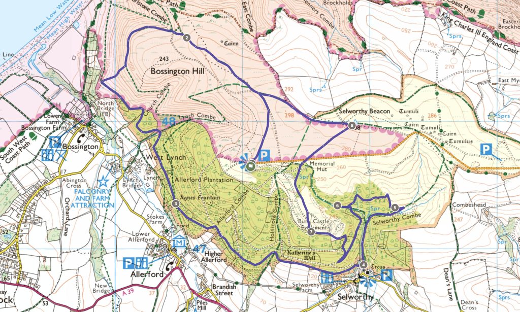
📍 Stage 5: Lady Acland’s Hut to Bury Castle
Grid Reference: SS 924 472
Cumulative Distance: 3.5 to 4.3 miles At a fork marked by a large stone, bear left and continue uphill. You’ll pass a blue-topped bridleway marker as you climb. After passing a second bridleway marker, turn sharp left and make your way up to Lady Acland’s Hut. This wooden shelter was built around 1879 for Gertrude, wife of Sir Charles Dyke Acland, possibly as a location for family picnics. The footpath continues past the hut. On reaching a wide stone-based track, bear left downhill. Then, almost immediately, turn right. After crossing a stream, follow a narrow unsigned footpath. Pass through a gate and continue ahead, following the signpost for ‘Bury Castle’. At the next junction, bear right uphill signposted ‘Bury Castle’. At a second junction, again bear right uphill signposted ‘Bury Castle’. Pass through a gate and as you emerge from the woodland, continue uphill until you reach a grassy path. The Iron Age Fort of Bury Castle lies to the right. However, the walk continues by bearing left along a grassy path with the woodland boundary on your left.
Historical note: Although called a ‘castle’, Bury Castle is an Iron Age enclosure that probably held a small farming community, dating to around 400 BC. Take time to explore the grassy ramparts and imagine life here over 2,000 years ago.
📍 Stage 6: Selworthy Beacon Summit
Grid Reference: SS 924 479
Cumulative Distance: 4.3 to 5 miles At a signpost marked ‘Selworthy Beacon ¾’, turn right uphill on another wide grassy path. This path passes through gorse, bracken, and birch trees. At a junction, bear right signposted ‘Selworthy Beacon’. Make your way past the stone Acland shelter and cross the road. Then climb uphill on a stony track until you reach Selworthy Beacon (308m / 1,010ft). This is the highlight of the walk. On a clear day, the panoramic views are exceptional:
- North: Across the Bristol Channel to the Welsh coast
- West: Along the dramatic Exmoor coastline
- South: Across rolling moorland towards Dunkery Beacon
- East: Over Porlock Vale and beyond
Consequently, it’s the perfect spot for a rest and a packed lunch.
Photo opportunity: The 360-degree panorama from Selworthy Beacon is one of the finest viewpoints in Exmoor National Park. Therefore, allow plenty of time here on a clear day.
📍 Stage 7: Descending from the Beacon
Grid Reference: SS 919 480
Cumulative Distance: 5 to 5.8 miles From Selworthy Beacon, turn left and walk downhill, heading west. Continue ahead as the South West Coast Path joins from the right. You’ll see a signpost marked ‘Coast Path, Bridleway, Bossington 2’. At a fork in the path, bear left. Throughout this section, views across Porlock Bay accompany your descent.
Navigation tip: Simply follow signs for Bossington. The path is clear and well-maintained, descending through open moorland with spectacular coastal views throughout.
📍 Stage 8: Return to Bossington
Grid Reference: SS 897 479
Cumulative Distance: 5.8 to 6.5 miles (finish) Shortly after the fork, at a second junction, turn sharp left. This descends back to the car park on the same path you started on at the beginning of the walk. The final section retraces your outward route, descending through grassland. Soon, the chocolate-box cottages of Bossington come into view below.
Finishing point: You’re back at the National Trust car park where you started. The village of Bossington with its thatched cottages is just steps away. Kitnors Kitchen tearoom is perfect for post-walk refreshments. Alternatively, head to nearby Porlock for pub options.
👀 What You’ll See on the Bossington Hill Circular Walk
One of the joys of this Bossington Hill circular walk is the extraordinary variety of landscapes, wildlife, history, and features you’ll encounter. Below is a guide to the highlights along the way.
🌊 Coastal Scenery & Bristol Channel Views (Stages 1-2, 6-8)
The walk begins and ends with spectacular coastal scenery along the South West Coast Path:
- Porlock Bay – Sweeping views across the bay to Porlock Weir and the shingle ridge
- Bristol Channel – On clear days, views extend to the Welsh coast
- Hurlstone Point – Dramatic headland with nesting seabirds
- Selworthy Sand – The beach visible below the coastal path
- Fulmars & seabirds – Often seen soaring along the cliffs
🌲 Selworthy Woods & Acland Heritage (Stages 3-5)
The woodland sections take you through the remarkable Holnicote Estate. This estate was given to the National Trust by Sir Richard Acland in 1944. Originally, it was established through the marriage of Sir Thomas Acland to local heiress Elizabeth Dyke in 1745.
- St Agnes Fountain – Built 1820 by Sir Thomas Acland for his daughter
- Selworthy Woods – Over a million trees planted in the 19th century
- Memorial Hut – Stone shelter with carved poetry from 1878
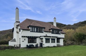
- Lady Acland’s Hut – Wooden shelter built 1879 for family picnics
- Selworthy Cross – 7-metre wooden cross with Latin inscription from Psalm 148
- Mitcham Seat – Another memorial feature in the woods
- Ancient oak & beech – Magnificent mature trees throughout
- Bluebells – Carpeting the woodland floor in May
![]()
Photo by Neville Stanikk
🏛️ Historical Features
The walk is rich in historical interest: Bury Castle is an Iron Age hillfort dating to approximately 400 BC (Stage 5). Despite its name, it wasn’t a castle but probably a small farming settlement. You can explore the grassy ramparts and imagine life on Exmoor over 2,400 years ago. Selworthy Green features the famous whitewashed, thatched cottages built in 1828 by the 10th Baronet Acland. Originally, these served as almshouses for retired estate workers. In return for their accommodation, the pensioners maintained the surrounding woodland paths. All Saints Church, Selworthy is a 15th-century church with distinctive white tower. Inside, you’ll find beautiful barrel-vaulted ceilings. Moreover, it offers one of the finest viewpoints in Somerset.
🏔️ Moorland & Summit Views (Stage 6)
Selworthy Beacon (308m) offers outstanding panoramic views:
- Wales – Visible across the Bristol Channel on clear days
- Exmoor coastline – Stretching west towards Lynmouth
- Dunkery Beacon – Exmoor’s highest point visible to the south
- Porlock Vale – Patchwork of fields spread below
- Heather moorland – Purple in August-September
- Exmoor ponies – Sometimes grazing on the open moorland
📸 Best Photo Opportunities
- Bossington thatched cottages (Start) – Classic Exmoor village scene
- Coastal views from Stage 1 – Porlock Bay and Bristol Channel
- Hurlstone Point (Stage 1) – Dramatic headland
- St Agnes Fountain (Stage 3) – Peaceful woodland glade
- Selworthy Green (Stage 3) – Famous whitewashed cottages
- All Saints Church (Stage 3) – White tower against green hills
- Woodland paths (Stages 4-5) – Dappled light through ancient trees
- Bury Castle ramparts (Stage 5) – Atmospheric Iron Age site
- Selworthy Beacon summit (Stage 6) – 360° panoramic views
- Final descent (Stage 8) – Looking down to Bossington
Ready to Walk the Bossington Hill Circular?
Make Bossington or Allerford your base and explore the best of Exmoor from your doorstep. Browse our holiday cottages in the Porlock Vale – perfect for walking holidays with stunning trails from the door.
🚗 Parking & Getting to the Bossington Hill Circular Walk
Where to Park
Bossington National Trust Car Park (Start Point for Walk)
Location: Centre of Bossington village
Postcode: TA24 8HF
Grid Reference: SS 897 479
Capacity: Approximately 30-40 spaces
Cost: £5 per day (free for National Trust members)
Facilities: None on-site (Kitnors Kitchen tearoom nearby) Parking Tips:
- ✅ Arrive early on busy days (weekends, Bank Holidays, summer) – the car park fills quickly
- ✅ Walk starts immediately from the car park heading northeast towards the coast
- ✅ National Trust members park free – remember to bring your membership card
- ✅ Alternative parking – Porlock (1 mile away) has additional car parks
- ✅ Support local businesses – Visit Kitnors Kitchen or Periwinkle Tearoom
Alternative Start Point
The official Exmoor Classics route starts from North Hill car park:
- Postcode: TA24 8TP
- Grid Reference: SS 910 476
- What3Words: slung.pillows.cloak
- Facilities: Toilets available in Minehead
However, starting from Bossington offers easier access, better parking, and tearoom facilities at both ends of the walk.
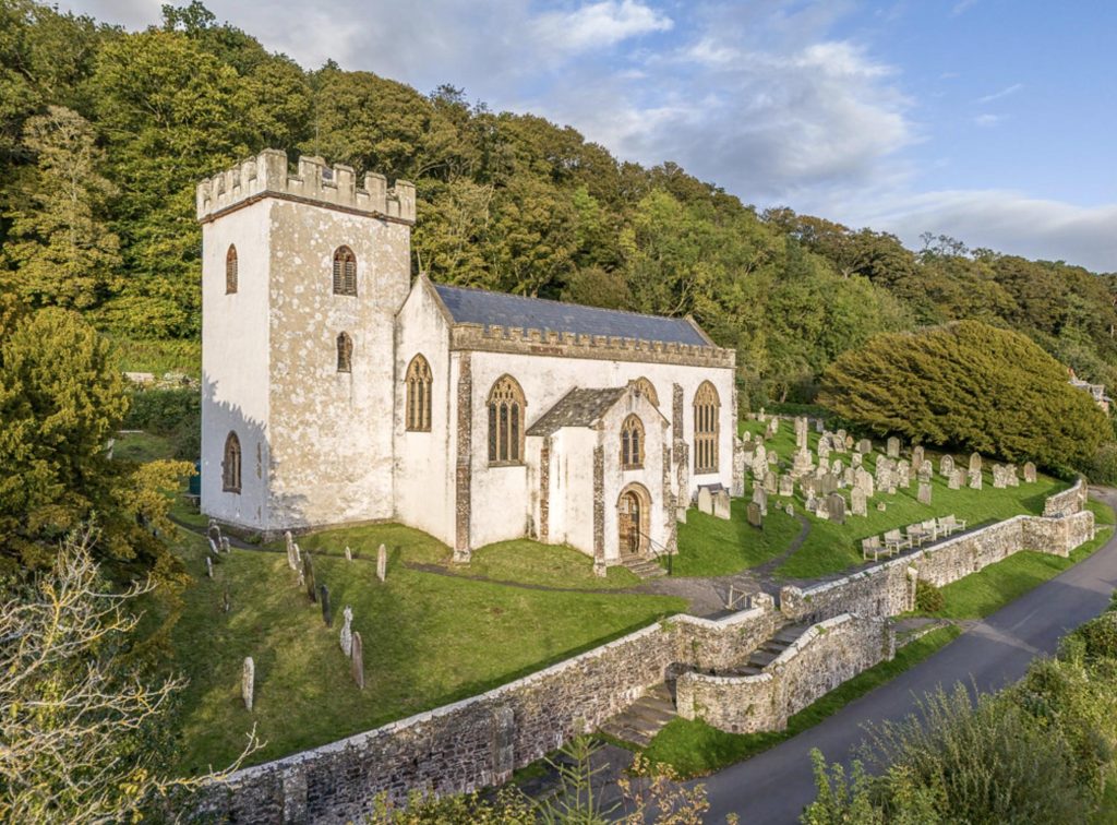
Photo by Shaun Davey
Getting to Bossington by Car
Bossington is located on the north coast of Exmoor:
- From Porlock: 1 mile east along minor road (5 minutes)
- From Minehead: 5 miles via A39 then minor roads (15 minutes)
- From Dunster: 8 miles via A39 (20 minutes)
- From Dulverton: 15 miles via B3224 and A39 (30 minutes)
- From Taunton: 30 miles via A358 and A39 (50 minutes)
- From Exeter: 45 miles via A361 and A39 (1 hour 10 minutes)
Road Note: The final approach to Bossington is via narrow lanes with passing places. Therefore, drive carefully and be prepared to reverse.
Public Transport
Limited options are available:
- Nearest Train Station: Taunton (30 miles) – taxi or rental car needed
- Buses: Limited service to Porlock (1 mile from Bossington)
- Best option: Arrive by car or stay locally and walk from accommodation
🏡 Where to Stay Near Bossington for Walking
Staying in or near Bossington, Allerford, or Selworthy puts you right at the heart of the Holnicote Estate. As a result, you’ll be within easy reach of this spectacular walk and many others. Here are our recommended holiday cottages perfect for Exmoor walking holidays:
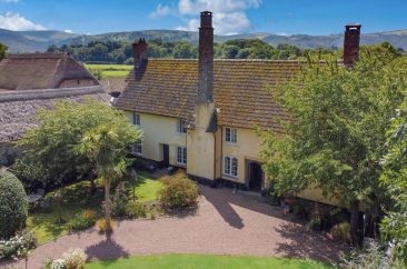
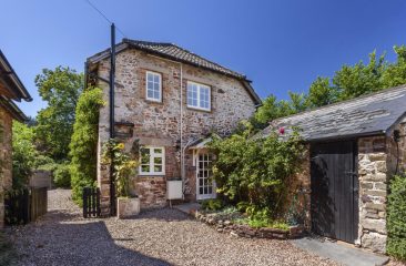


Browse our complete collection of holiday cottages in and around Selworthy.
⚠️ Practical Information & Safety
What to Bring – Essential Items
✅ Must-Have Items:
- Walking boots – Essential because paths can be muddy and uneven
- OS Map – Explorer OL9 Exmoor (essential backup even with detailed directions)
- Waterproof jacket – Exmoor weather changes quickly, particularly on exposed moorland
- Water – Minimum 1.5 litres per person for this longer walk
- Snacks/lunch – Although Periwinkle Tearoom is at the midpoint, bring supplies
- Mobile phone – For emergencies (signal generally good throughout)
- This route description – Printed or downloaded for reference
☑️ Recommended Items:
- Walking poles – Helpful on descents and climbs, especially in wet conditions
- Sun protection – Hat and sunscreen for exposed moorland sections
- Extra warm layer – It can be cold on the beacon even in summer
- Camera – Many photo opportunities throughout the walk
- Binoculars – Useful for coastal views and wildlife spotting
- Cash – For Periwinkle Tearoom and Kitnors Kitchen
Weather Considerations
Exmoor weather is notoriously changeable, so always check the forecast:
- Summer (June-August): Generally offers the best conditions. However, moorland can be hot with little shade. This is when Periwinkle Tearoom is busiest.
- Autumn (September-November): Beautiful autumn colours appear in the woods. The heather is at its best in September. Nevertheless, paths become muddier, especially in woodland sections.
- Winter (December-February): Short days mean you should start early. It can be very cold on the exposed beacon. Additionally, woodland paths can be very muddy.
- Spring (March-May): Spectacular bluebells appear in May. Weather is variable but often good. Note that this is lambing season, so extra care with dogs is required.
Important: Selworthy Beacon is exposed and can be unpleasant in strong wind, heavy rain, or poor visibility.
Safety Considerations
⚠️ Important Safety Points:
- Tell someone your plans and expected return time (allow 4-5 hours to be safe)
- Check weather forecast before setting out on your walk
- Carry OS map – Don’t rely solely on these directions or phone GPS
- Livestock present throughout – Cattle and sheep graze across the Holnicote Estate
- Close all gates behind you to keep livestock secure
- Cliff edges – Take care on the coastal sections near Hurlstone Point
- Emergency: Dial 999 or 112. For mountain rescue, ask for “Police” then “Exmoor Search and Rescue”
Walking with Dogs
Dogs are welcome on this walk. However, please note:
- ✅ Keep on leads throughout – The Holnicote Estate has grazing cattle and sheep
- ✅ Bag and bin dog waste (bins available in Bossington and Selworthy)
- ⚠️ Spring lambing – Extra care required from March to May
- ⚠️ No stiles – Gates throughout, making it suitable for dogs of all sizes
- Water for dogs – Streams are available at several points along the route
The leaflet notes: “There are no stiles or obstacles that are likely to prevent your dog from completing the walk.”
Best Time of Year & Day
Perfect Months to Visit:
- May: Spectacular bluebells in Selworthy Woods
- June-September: Best weather conditions and longer daylight
- August-September: Purple heather on moorland sections
- October: Beautiful autumn colours in woodland areas
Best Time of Day:
- 9-10am start: Provides good light for photos and avoids parking issues
- Allow 4+ hours for comfortable completion with stops for refreshments
- Winter: Start by 11am to finish before dark (sunset around 4pm)
Accessibility
This walk is NOT suitable for:
- ❌ Wheelchairs – Multiple gates, uneven terrain, and steep sections
- ❌ Pushchairs – Rough paths make this impossible
- ❌ Very young children – The 6.5-mile distance with significant elevation is too demanding
- ❌ People with mobility issues – Sustained climbs and descents required
✅ Suitable for: Fit adults, families with children 10+ who regularly walk, and experienced walkers.
Frequently Asked Questions About the Bossington Hill Circular Walk
How long does the Bossington Hill circular walk take?
Where do I park for the Bossington Hill circular walk?
Is there somewhere to get refreshments on this walk?
Is the Bossington Hill circular walk suitable for dogs?
What’s the best time of year for the Bossington Hill circular walk?
How difficult is the Bossington Hill circular walk?
Can I see the Welsh coast from this walk?
What is Bury Castle on this walk?
Can I do a shorter version of this walk?
Is mobile phone signal available on this walk?
🔗 More Exmoor Walks You’ll Enjoy
If you enjoyed this Bossington Hill circular walk, explore these other Exmoor walking routes:
More Walks in the Porlock Vale Area:
- 🌲 Dunkery & Horner Wood Walk – Beautiful woodland walk (3 miles, 1 hour)
- 🌊 Porlock Weir to Porlock Circular – Coastal and woodland (4 miles)
- 🏔️ Dunkery Beacon from Webbers Post – Summit of Exmoor’s highest point
Similar Moderate Circular Walks on Exmoor:
- 🏰 Dunster Circular Walk – Castle, woodland and Bat’s Castle (4.3 miles)
- ⛰️ Wheddon Cross to Dunkery Beacon – Exmoor’s highest summit (8 miles)
- 🌊 Valley of Rocks Circular – Dramatic coastal scenery (3.5 miles)
Explore the Local Area:
- 🏘️ Bossington & Allerford Village Guide – Everything to see and do
- 🏘️ Porlock Village Guide – Pubs, restaurants and attractions
Walking Resources:
Browse all our Exmoor circular walks.
Final Thoughts: Completing the Bossington Hill Circular Walk
The Bossington Hill circular walk is one of the finest walks in Exmoor National Park. It offers an extraordinary variety of landscapes in a single day.
You’ll experience dramatic coastal scenery along the South West Coast Path. You’ll wander through enchanting ancient woodlands planted by the Acland family. And you’ll climb to the panoramic summit of Selworthy Beacon. This walk captures the very essence of what makes Exmoor so special.
The historical interest adds considerable depth to the experience. Walk in the footsteps of the Acland family who shaped this landscape over centuries. Explore an Iron Age hillfort dating back 2,400 years. Discover the story behind Selworthy’s famous whitewashed cottages. This is a walk that engages the imagination as much as the legs.
Moreover, with the Periwinkle Tearoom perfectly positioned at the midpoint, you can combine serious walking with cream tea in a picture-perfect setting. The quintessential Exmoor experience.
- ✅ Carry OS Explorer Map OL9 Exmoor
- ✅ Check weather forecast before setting out
- ✅ Tell someone your plans
- ✅ Close all gates (livestock grazing throughout)
- ✅ Keep dogs on leads
- ✅ Bring water and snacks
- ✅ Allow 4 hours for comfortable completion
- ✅ Bring cash for the tearooms!
📝 Route Information & Disclaimer
Route Sources: This walking guide has been compiled from official Exmoor National Park information (Exmoor Classics No.1), OS mapping, and local knowledge. The route passes through the National Trust’s Holnicote Estate. Last Verified: December 2025 Disclaimer: Walking routes can change due to weather, land management, livestock movement, or other factors. While we work to keep this guide accurate, always use appropriate OS maps (Explorer OL9 Exmoor), check current conditions, and make your own safety assessment before setting out. The Best of Exmoor accepts no responsibility for any issues encountered while following this route. Always follow the Countryside Code, respect farmland, keep gates closed, and keep dogs under control around livestock. Emergency Contacts: Dial 999 or 112 for emergencies. For mountain rescue, ask for “Police” then “Exmoor Search and Rescue”.
Happy walking! We hope you enjoy this spectacular Bossington Hill circular walk as much as we do.