☰
The Countisbury Circular Walk — Exmoor’s 10-Mile Coast & Combe Classic
River gorges, ancient oak woods and England’s only road-cut coastal cliff — the Countisbury Circular Walk is one of Exmoor’s most rewarding day walks. Stay in a handpicked cottage right on the route.
Browse Cottages →
The Countisbury Circular Walk is a full-day circuit through Exmoor’s deepest river gorges, ancient oak woodlands and the highest stretch of coast on the South West Coast Path. First, you drop down to Brendon village. Then you follow the East Lyn River to Watersmeet, climb to Countisbury, and finish along the coast past Foreland Lighthouse and Sisters Fountain.
Officially route No. 3 in the Exmoor Classics series, the Countisbury Circular Walk starts at County Gate on the Devon/Somerset border. From there, the path drops through woodland to Brendon, follows the East Lyn River downstream to Watersmeet, climbs through Trilly Ridge to Countisbury, and then runs east along the South West Coast Path. Eventually, after passing Foreland Lighthouse, Glenthorne Cliffs and Sisters Fountain, the route returns to the car park via Seven Thorns.
At 16.7 km (about ten miles) with 855 metres of ascent, this is a serious day’s walking. However, the Countisbury Circular Walk packs riverside paths, two of England’s rarest woodlands, England’s only road-cut coastal cliff and a piece of lifeboat history into a single circuit. As a result, it consistently ranks among Exmoor’s top-rated long walks.
The Countisbury Circular Walk in This Guide
1. Quick Facts About the Countisbury Circular Walk
- Distance: 16.7 km (about ten miles)
- Total ascent: 855 metres (2,805 feet)
- Duration: About four to five hours of walking time
- Difficulty: Challenging — a full day with significant climbs out of the East Lyn valley and onto the coast
- Start / end: County Gate Car Park, A39 (between Lynmouth and Porlock)
- Postcode: EX35 6NG · Grid: SS 793 486 · what3words: preheated.costly.headache
- Terrain: Woodland tracks, riverside paths, coastal grassland and short sections of quiet road
- Dog-friendly: Yes — keep dogs on a lead near livestock and ground-nesting birds
- Toilets: County Gate car park & Watersmeet Tea Rooms (NT, seasonal)
- Refreshments: Stag Hunters Inn (Brendon), Rockford Inn, Watersmeet Tearooms (NT), Blue Ball Inn (Countisbury)
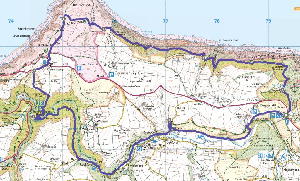
2. Countisbury Circular Walk Route Directions
Eight waypoints take you round the full Countisbury Circular Walk. First, you drop down into the East Lyn valley to Brendon. Then the route follows the river to Watersmeet, climbs through Trilly Ridge to Countisbury, and finally returns along the South West Coast Path via Foreland Lighthouse and Sisters Fountain.
Stage 1 — County Gate to Hall Farm
First, leave the western end of the car park taking the footpath signposted Public Footpath Brendon 1¾. At a junction of paths, pass through a gate and join the Coleridge Way, as indicated by the quill motif on the fingerpost. Then continue along this footpath as it drops gently through the woods. Eventually the path drops more steeply downhill, coming out via some steps onto the road at Hall Farm.
Stage 2 — Brendon Village & the East Lyn
Next, turn left along the road, still following the Coleridge Way quill. Then enter the village of Brendon, passing the road bridge over the East Lyn River. Just after a packhorse bridge, leave the road and join a footpath on the left, signposted Rockford 1 and on towards Watersmeet. The path runs along the riverbank and is marked with regular signposts and waymarkers. Of course, the Stag Hunters Inn in Brendon and the Rockford Inn just downstream both make excellent refuelling stops if you set off early.
Stage 3 — Watersmeet & Trilly Ridge
At the waymarker Watersmeet ¼, take the footpath uphill with the wall on your right. Walk uphill through Trilly Ridge. As you emerge from the woods, bear left and continue the zig-zags uphill along Trilly Ridge. Finally, at a junction of paths, follow the South Countisbury fingerpost, signposted Countisbury ¼, and continue uphill towards the A39.
Stage 4 — Countisbury Church to Foreland Point
After crossing the busy A39, follow a path uphill into a field. Walk uphill with West Coast Path Lynmouth ¼ on your right. Then turn right and continue along the SWCP, signposted South Countisbury. Continue ahead past Countisbury Church. At a junction of paths, follow the path signposted Public Footpath Lynmouth 2. After passing a pond on your right, turn left and walk uphill to a signpost signposted Footpath Countisbury via A39 ¼, and pass through a gate.
Stage 5 — Foreland Lighthouse
At the next junction, take the Coast Path Porlock 11, signposted Coast Path. At the next junction of paths, turn right. Then the path runs along the edge of the hill and drops via some steps round to the road that serves Foreland Lighthouse. On reaching the road, turn right and walk uphill. Importantly, a short out-and-back down the lane takes you to the lighthouse itself — the most northerly point on the Devon coast, perched 70 metres above the sea.
Stage 6 — Glenthorne Cliffs & Chubhill Combe
As the road bears round to the right, continue ahead on the signposted Coast Path Glenthorne Cliffs 3. Then at the National Trust sign for Glenthorne Cliffs, take the footpath on the right, signposted Coast Path. Continue along this woodland path, passing over Chubhill Combe, before coming out at a junction of paths.
Stage 7 — Glenthorne House & Sisters Fountain
Next, turn left, signposted Coast Path Porlock Weir 8. Follow the coast path as it crosses over several combes before it eventually joins the drive through Glenthorne House. Then turn right and follow the drive uphill, signposted Coast Path. After passing the greenway to Glenthorne, take the footpath to the left of the drive, signposted Coast Path Culbone 4. Finally, the coast path takes you past Sisters Fountain, a small spring-head dating from 1829 and marked by a stone known as the Decision Stone.
Stage 8 — Seven Thorns Back to County Gate
At the top of some steps, turn right, leaving the Coast Path and following the path signposted Public Footpath County Gate. Then at a junction known as Seven Thorns, turn left, signposted Public Footpath. Go through a tall deer gate and follow the track as it climbs steeply uphill. After a second deer gate, follow the path as it continues uphill towards the A39. Finally, cross over the A39 to get back to the car park and complete the Countisbury Circular Walk.
3. Highlights Along the Countisbury Circular Walk
County Gate
The walk starts at County Gate on the Devon/Somerset border. Indeed, there was a gate here in years gone by, and the stone posts can still be found in the wall. Furthermore, in the 1920s the Lynton stagecoaches ran along the road, which can be seen in the current car park.
The East Lyn River
The East Lyn is one of Exmoor’s main rivers. It is formed by the meeting of Oare Water and Badgworthy Water below Malmsmead. Then it flows past Brendon and Rockford, joining the West Lyn at Lynmouth before reaching the Bristol Channel.
Watersmeet
Watersmeet is the confluence of the East Lyn and Hoar Oak Water, set in a deep gorge of ancient oak woodland and owned by the National Trust. Usefully, the tea rooms, open seasonally in a Victorian fishing lodge above the waterfalls, are the essential refuelling stop roughly a third of the way round the Countisbury Circular Walk.
Countisbury Church
Countisbury Church, dedicated to St John the Evangelist, was largely rebuilt in 1846 by the Revd Halliday. In the graveyard, you can find the graves of two Canadian sailors from a 19th-century shipwreck off Foreland Point — a reminder of the brutal sea below the headland.
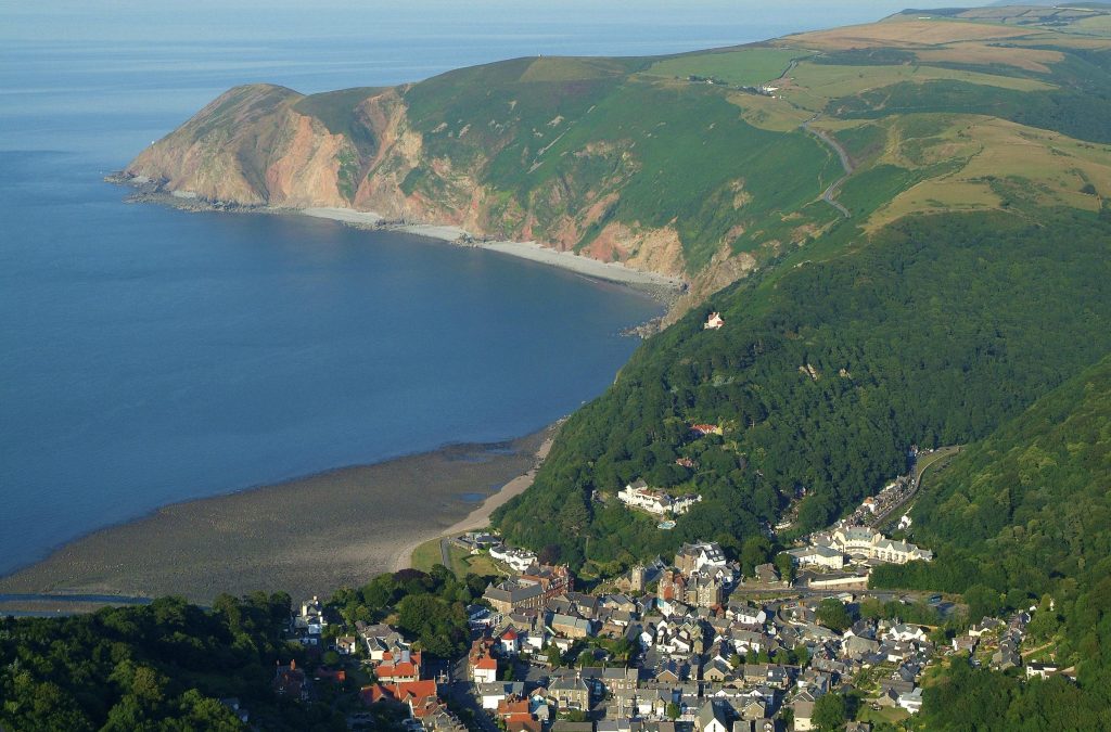
Foreland Point & Lighthouse
Foreland Point is the most northerly point on the Devon coast. Built in 1900, Foreland Lighthouse sits 70 metres above the sea. Notably, it is the location of Exmoor’s only road cut into the coastal cliff — a vertiginous descent that has to be seen to be believed.
Image Credit: Neville Stanikk
Exmoor’s Coastal Woodlands
Along the South West Coast Path, the Countisbury Circular Walk passes through some of the longest stretches of coastal woodland in England and Wales. Additionally, these woods are home to exceptionally rare endemic whitebeams — including the bloody whitebeam and the Somerset whitebeam, found nowhere else in the world.
Sisters Fountain
Dating from the 19th century, Sisters Fountain marks the head of a spring built on the hillside above Glenthorne House. Construction started in 1829, marked by a small inscribed stone known as the Decision Stone. According to local tradition, it is the spot where the Revd Halliday made the decision to build Glenthorne House.
Stay in Countisbury & Lynmouth
Yenworthy Cottage, Countisbury
Sleeps 6 · 3 Bedrooms
Book
Dashel Cottage, Countisbury
Sleeps 6 · 3 Bedrooms
Book

Lorna Doone Cottage, Lynmouth
Sleeps 4 · 2 Bedrooms
Book
4. History & Heritage on the Countisbury Circular Walk
The Louisa & the Rescue of the SS Forrest Hall
The steep hill at Countisbury — with a gradient of 1 in 5 — was the scene of perhaps the most difficult lifeboat launch in the history of the RNLI. On the night of 12 January 1899, the alarm was raised after the SS Forrest Hall began to founder in Porlock Bay. However, the Lynmouth lifeboat Louisa was unable to launch from the harbour due to high seas.
Consequently, the decision was taken to haul the boat up Countisbury Hill and then on to Porlock, after ten hours overland — thirteen miles in total. Finally, the boat was launched at Porlock Weir and the SS Forrest Hall crew were escorted to safety.
The 1952 Lynmouth Flood
On the night of 15 August 1952, the equivalent of three months’ rain — about 230 mm — fell on the high moors above the East Lyn. As a result, the resulting torrent grew in size and ferocity as it flowed down to the coast at Lynmouth, carrying boulders, soil and trees through the narrow valleys.
Much of the small town of Lynmouth and the village of Barbrook was destroyed in a single night, and thirty-four people lost their lives. Importantly, the Countisbury Circular Walk follows the upper reaches of the river system that caused the disaster — sobering, especially after heavy rain.
The Exmoor Classics Series
The Countisbury Circular Walk is route No. 3 in the
Exmoor Classics, the Exmoor National Park’s series of twelve longer waymarked walks. Other routes include Bossington Hill, Combe Martin & Great Hangman, Dunster & Bats Castle, Valley of Rocks and Winsford & the Punchbowl. Leaflets are available from National Park Centres at Dunster, Dulverton and Lynmouth, or as digital maps from
exmoorwalks.org. For more walking inspiration, see our
full collection of Exmoor circular walks.
Stay in Brendon, Rockford & Oare

Riverside Cottage, Brendon
Sleeps 4 · 2 Bedrooms
Book

Rockford Cottage, Brendon
Sleeps 9 · 4 Bedrooms
Book

Oare Manor Cottage, Malmsmead
Sleeps 6 · 3 Bedrooms
Book
5. Practical Information for the Countisbury Circular Walk
Getting There & Parking
The Countisbury Circular Walk starts and ends at County Gate Car Park on the A39, on the Devon/Somerset border between Lynmouth and Porlock. The postcode is EX35 6NG, grid SS 793 486, what3words preheated.costly.headache. Additionally, there are toilets in the car park and a seasonal refreshment kiosk in summer.
Refreshments on the Route
In order of appearance: Stag Hunters Inn (Brendon), Rockford Inn (Rockford), Watersmeet Tearooms (NT, seasonal), Blue Ball Inn (Countisbury). However, after Countisbury there are no facilities until you return to County Gate — so carry water and snacks for the coastal section. For more options, see our
guide to the best pubs on Exmoor.
Dogs on the Countisbury Circular Walk
Dogs are welcome on this walk. However, please keep them under close control at all times. Sheep and lambs grazing on the moor can be injured or killed by even friendly dogs. If you feel threatened by cattle, drop the lead and move away, especially when they’re protecting their calves. Additionally, there may be wild animals like red deer and ground-nesting birds that could be disturbed by your dog. Finally, bag any waste and take it with you until you reach a dog bin.
What to Wear
- Footwear: Sturdy walking boots with good grip — the coast path has steep, uneven sections and the woodland tracks can be muddy after rain
- Layers: The clifftop section from Countisbury to Sisters Fountain is exposed — be prepared for wind, even on warm days
- Waterproofs: Weather can change quickly on the coast
- Map: OS Explorer OL9 (Exmoor) or the Exmoor Classics No. 3 leaflet
Waymarking
First, the outward route follows the Coleridge Way (quill motif) and then fingerposts towards Rockford and Watersmeet. Then the return follows the South West Coast Path, marked by the acorn motif throughout. Importantly, all rights of way on Exmoor use handmade fingerposts — footpaths waymarked with a yellow tip, bridleways with a blue tip.
Safety Note
The Countisbury Circular Walk is a long day’s walk with 855 metres of total ascent and very exposed sections along Foreland and Glenthorne Cliffs. Therefore, start early — allow at least four to five hours of walking time plus stops. Furthermore, the descent to Foreland Lighthouse and the climb out of Seven Thorns are both steep. After heavy rain, the East Lyn path can be slippery and high water levels can make stepping stones impassable.
6. Where to Stay near the Countisbury Circular Walk
The Countisbury Circular Walk passes within a stone’s throw of some of Exmoor’s most beautiful villages — Brendon, Rockford, Countisbury and Oare. Below are three more handpicked cottages on or beside the route, from a couples’ retreat in Lynton to a 13-guest farmhouse in Countisbury itself. Additionally, you can browse the
Porlock visitors guide if you want to extend your stay further east, or our
Exmoor map and area guide for the bigger picture.
More Cottages near the Countisbury Circular Walk

The Cottage at Woodlands, Lynton
Sleeps 2 · 1 Bedroom
Book

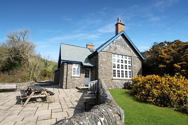
Wingate Farm, Countisbury
Sleeps 8 · 4 Bedrooms
Book
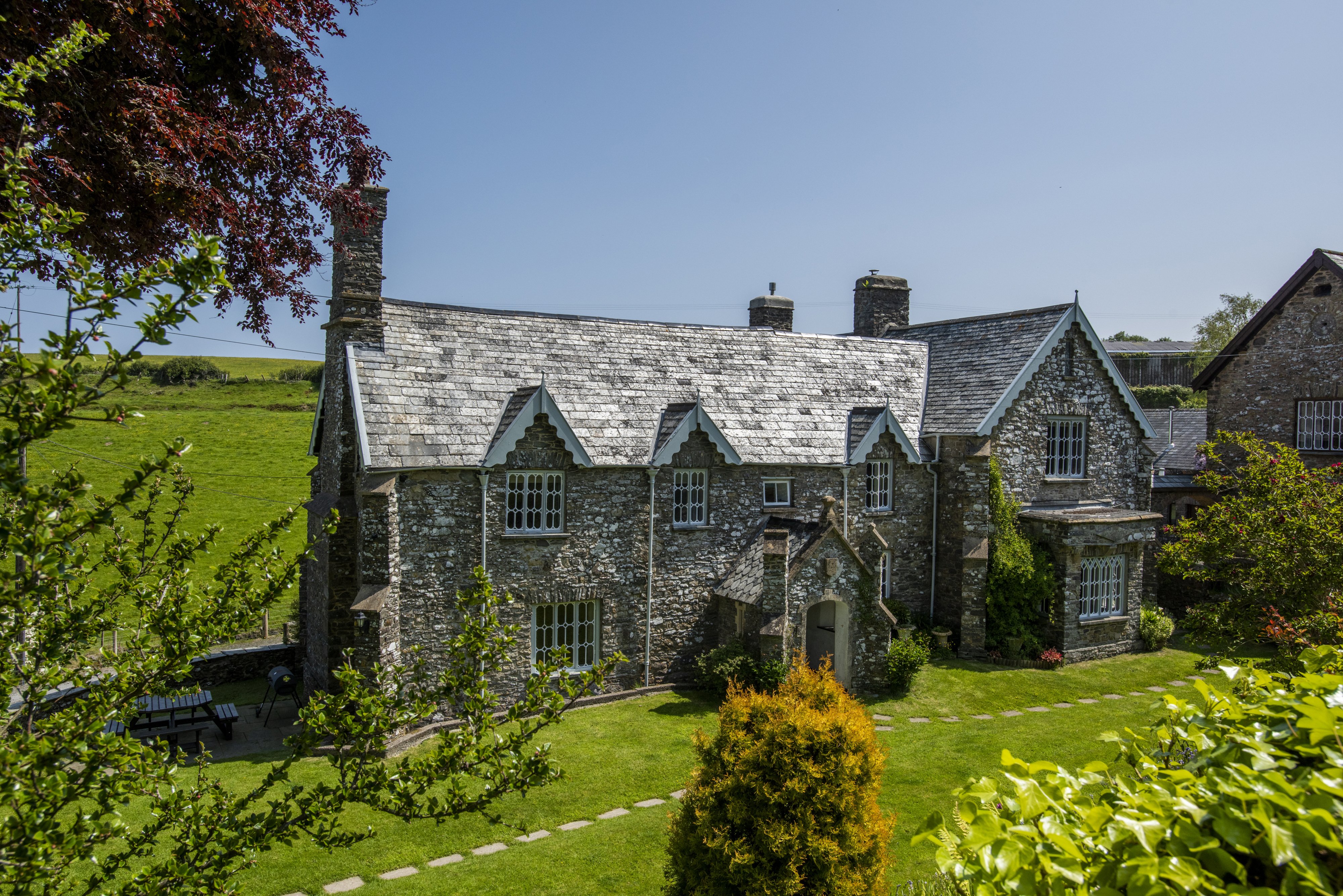
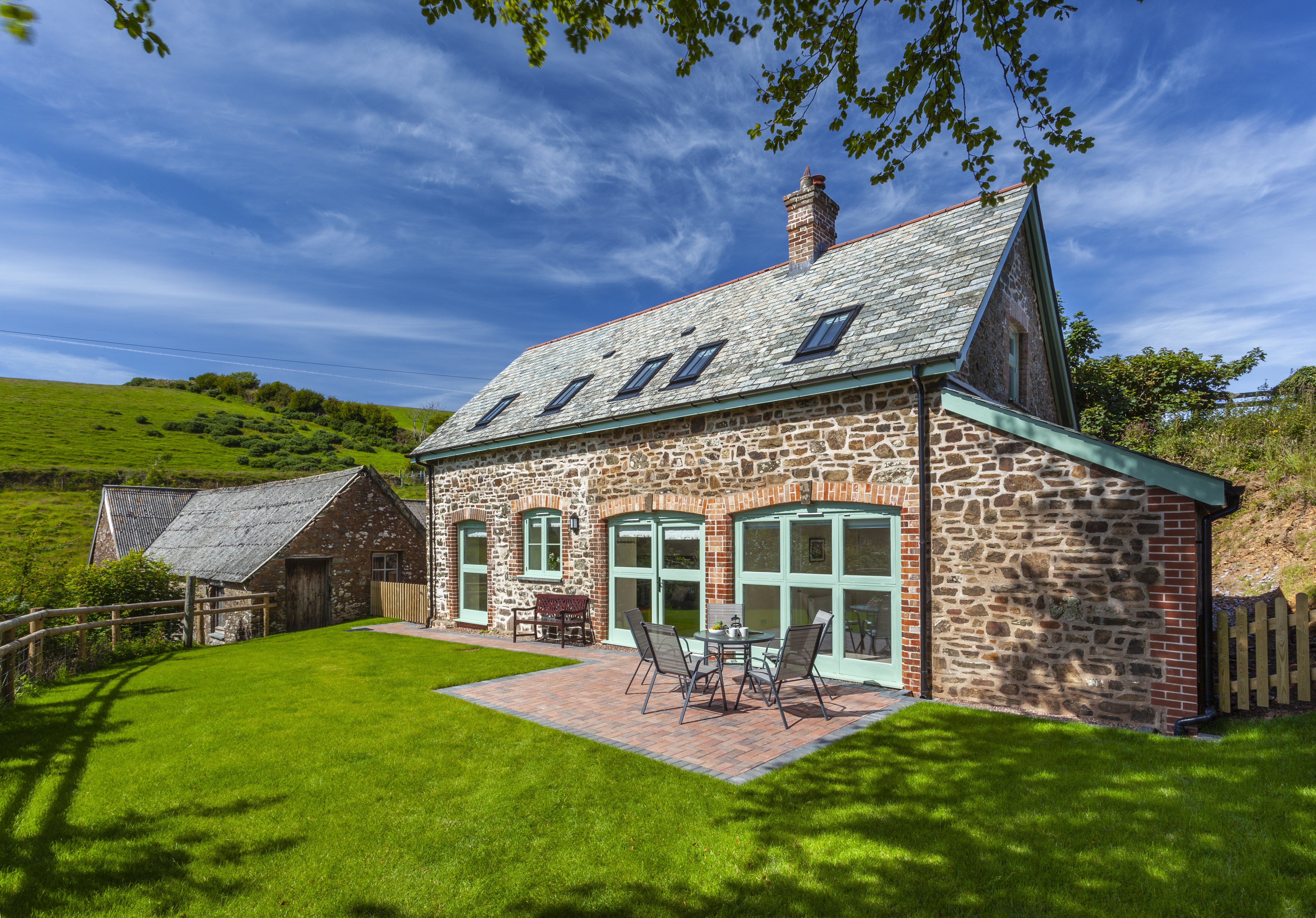
The School House, Countisbury
Sleeps 13 · 6 Bedrooms
Book
Frequently Asked Questions
How long does the Countisbury Circular Walk take?
Typically, allow four to five hours of walking time for the full 16.7 km (10 mile) Countisbury Circular Walk, plus extra for lunch at Watersmeet or one of the inns. However, most walkers complete it in around six hours including stops.
How difficult is the Countisbury Circular Walk?
Overall, this is a challenging walk. Specifically, there’s 855 metres (2,805 feet) of total ascent, with two big climbs out of the East Lyn valley and onto Countisbury, plus exposed coastal sections from Foreland to Glenthorne. Therefore, you’ll need a reasonable level of fitness, decent boots and a full day’s daylight.
Where do I park for the Countisbury Circular Walk?
Park at County Gate Car Park on the A39 (postcode EX35 6NG, grid SS 793 486). Importantly, the walk leaves from the western end of the car park. Additionally, there are toilets at the car park and a seasonal refreshment kiosk in summer.
Are there pubs or cafés along the route?
Yes — you’ll pass the Stag Hunters Inn in Brendon, the Rockford Inn at Rockford, the National Trust Watersmeet Tearooms (seasonal) and the Blue Ball Inn at Countisbury. Generally, the Watersmeet stop, roughly a third of the way round, is the most popular lunch break.
Is the Countisbury Circular Walk suitable for dogs?
Yes. However, please keep them under close control — there are sheep, cattle and red deer on the coastal section, and ground-nesting birds in spring. Finally, bag waste and take it with you until you reach a bin.
What is the best time of year for the Countisbury Circular Walk?
Generally, late spring to early autumn offers the best conditions — longer days, drier paths and the East Lyn woodlands at their best. For example, May brings bluebells through Trilly Ridge, while October paints the oak gorges of Watersmeet in copper and gold. However, winter is doable in clear weather but the river path can flood and the coastal section is very exposed.
Ready to Walk the Countisbury Circular Walk?
Browse our collection of hand-picked holiday cottages in Countisbury, Brendon, Lynmouth and Oare — all within minutes of one of Exmoor’s finest circular walks.
Browse Cottages →
THE BEST OF EXMOOR
We’re a tiny, passionate team of locals who know and love Exmoor. Our mission is simple: to help you find your perfect holiday while showcasing the best this incredible area has to offer.
© 2026 The Best of Exmoor. All rights reserved.